Capstone Project - The Battle of the Neighborhoods (Week 2)
Applied Data Science Capstone by IBM
By Diego
Hidalgo
Table of contents
- Introduction: Business Problem
- Data
- Methodology
- Analysis
- Results and Discussion
- Conclusion
In this project we will try to find an optimal location for a restaurant.
Specifically, this report will be targeted to stakeholders interested in
opening an Italian restaurant in Chicago, IL US.
Since there are lots of restaurants in Chicago we will try to detect locations
that are not already crowded with restaurants. We are also particularly
interested in areas with no Italian restaurants in vicinity. We would
also prefer locations as close to city east as possible, assuming that
first two conditions are met.
We will use our data science powers to generate a few most promissing
neighborhoods based on this criteria. Advantages of each area will then be
clearly expressed so that best possible final location can be chosen by
stakeholders.
Based on definition of our problem, factors that will influence our
decission are:
- number of existing restaurants in the neighborhood (any type of restaurant)
- number of and distance to Italian restaurants in the neighborhood, if any
- distance of neighborhood from city center
We decided to use regularly spaced grid of locations, centered around city
center, to define our neighborhoods.
Following data sources will be needed to extract/generate the required
information:
- centers of candidate areas will be generated algorithmically and approximate addresses of centers of those areas will be obtained using Google Maps API reverse geocoding
- number of restaurants and their type and location in every neighborhood will be obtained using Foursquare API
- coordinate of Chicago center will be obtained using Google Maps API geocoding
Neighborhood Candidates
Let's create latitude & longitude coordinates for centroids of our
candidate neighborhoods. We will create a grid of cells covering our area of
interest which is aprox. 12x12 killometers centered around Chicago city east.
Let's first find the latitude & longitude of Berlin city center, using
specific, well known address and Google Maps geocoding API.
Coordinate
of Chicago, IL, USA: [41.8781136, -87.6297982]
Now let's create a grid of area candidates, equaly spaced, centered around
city center and within ~6km from Chicago East. Our neighborhoods will be
defined as circular areas with a radius of 300 meters, so our neighborhood
centers will be 600 meters apart.
To accurately calculate distances we need to create our grid of locations
in Cartesian 2D coordinate system which allows us to calculate distances in
meters (not in latitude/longitude degrees). Then we'll project those
coordinates back to latitude/longitude degrees to be shown on Folium map. So
let's create functions to convert between WGS84 spherical coordinate system
(latitude/longitude degrees) and UTM Cartesian coordinate system (X/Y coordinates
in meters).
Coordinate transformation check
-------------------------------
Chicago center
longitude=-87.6297982, latitude=41.8781136
Chicago center UTM
X=-5379210.510659022, Y=11522384.948403545
Chicago
center longitude=-87.62979820000015, latitude=41.87811360000047
Let's create a hexagonal grid of cells: we offset every other row,
and adjust vertical row spacing so that every cell center is equally distant
from all it's neighbors.
364
candidate neighborhood centers generated.
Let's visualize the data we have so far: city center location and candidate
neighborhood centers:

OK, we now have the coordinates of centers of neighborhoods/areas to be
evaluated, equally spaced (distance from every point to it's neighbors is
exactly the same) and within ~6km from Chicago Center.
Let's now use Google Maps API to get approximate addresses of those
locations.
['1330 N LaSalle Dr, Chicago, IL 60610',
'1534 N Wells St, Chicago, IL 60610',
'242 W St Paul Ave, Chicago, IL 60614',
'25 Fort Dearborn Dr, Chicago, IL 60616',
'S Lake Shore Dr, Chicago, IL 60616',
'S Lake Shore Dr, Chicago, IL 60616',
'E 18th Dr, Chicago, IL 60605',
'13 S Lake Shore Dr, Chicago, IL 60605',
'1388 S Lake Shore Dr, Chicago, IL 60605',
'1158 S Columbus Dr, Chicago, IL 60605',
'150 E 11th Pl, Chicago, IL 60605',
'Michigan & Ida B Wells Drive, Chicago, IL
60605',
'215 S Wabash Ave, Chicago, IL 60604',
'17 N State St, Chicago, IL 60602',
'35 W Wacker Dr, Chicago, IL 60601',
'59 W Hubbard St, Chicago, IL 60654',
'631 N LaSalle Dr, Chicago, IL 60654',
'168198 W Chicago Ave, Chicago, IL 60654',
'219 W Oak St, Chicago, IL 60610',
'300 W Division, Chicago, IL 60610']
Looking good. Let's now place all this into a Pandas dataframe.
|
Address
|
Latitude
|
Longitude
|
X
|
Y
|
Distance from center
|
|
|
0
|
Cook County, IL
|
41.878741
|
-87.580104
|
-5.381011e+06
|
1.151667e+07
|
5992.495307
|
|
1
|
1000 E Grand Ave, Chicago, IL 60611
|
41.882270
|
-87.581676
|
-5.380411e+06
|
1.151667e+07
|
5840.376700
|
|
2
|
1000 E Grand Ave, Chicago, IL 60611
|
41.885798
|
-87.583248
|
-5.379811e+06
|
1.151667e+07
|
5747.173218
|
|
3
|
1000 E Grand Ave, Chicago, IL 60611
|
41.889327
|
-87.584821
|
-5.379211e+06
|
1.151667e+07
|
5715.767665
|
|
4
|
1000 E Grand Ave, Chicago, IL 60611
|
41.892856
|
-87.586394
|
-5.378611e+06
|
1.151667e+07
|
5747.173218
|
|
5
|
1000 E Grand Ave, Chicago, IL 60611
|
41.896385
|
-87.587967
|
-5.378011e+06
|
1.151667e+07
|
5840.376700
|
|
6
|
1003 E Ohio St, Chicago, IL 60611
|
41.899915
|
-87.589540
|
-5.377411e+06
|
1.151667e+07
|
5992.495307
|
|
7
|
Cook County, IL
|
41.872432
|
-87.581835
|
-5.381911e+06
|
1.151719e+07
|
5855.766389
|
|
8
|
Cook County, IL
|
41.875960
|
-87.583407
|
-5.381311e+06
|
1.151719e+07
|
5604.462508
|
|
9
|
1000 E Grand Ave, Chicago, IL 60611
|
41.879488
|
-87.584979
|
-5.380711e+06
|
1.151719e+07
|
5408.326913
|
...and let's now save/persist this data into local file.
df_locations.to_pickle('./locations.pkl')
Foursquare
Now that we have our location candidates, let's use Foursquare API to get
info on restaurants in each neighborhood.
We're interested in venues in 'food' category, but only those that are
proper restaurants - coffe shops, pizza places, bakeries etc. are not direct
competitors so we don't care about those. So we will include in out list only
venues that have 'restaurant' in category name, and we'll make sure to detect
and include all the subcategories of specific 'Italian restaurant' category, as
we need info on Italian restaurants in the neighborhood.
# Category
IDs corresponding to Italian restaurants were taken from Foursquare
food_category
= '4d4b7105d754a06374d81259' # 'Root' category for all food-related venues
italian_restaurant_categories
= ['4bf58dd8d48988d110941735','55a5a1ebe4b013909087cbb6','55a5a1ebe4b013909087cb7c',
'55a5a1ebe4b013909087cba7','55a5a1ebe4b013909087cba1','55a5a1ebe4b013909087cba4',
'55a5a1ebe4b013909087cb95','55a5a1ebe4b013909087cb89','55a5a1ebe4b013909087cb9b',
'55a5a1ebe4b013909087cb98','55a5a1ebe4b013909087cbbf','55a5a1ebe4b013909087cb79',
'55a5a1ebe4b013909087cbb0','55a5a1ebe4b013909087cbb3','55a5a1ebe4b013909087cb74',
'55a5a1ebe4b013909087cbaa','55a5a1ebe4b013909087cb83','55a5a1ebe4b013909087cb8c',
'55a5a1ebe4b013909087cb92','55a5a1ebe4b013909087cb8f','55a5a1ebe4b013909087cb86',
'55a5a1ebe4b013909087cbb9','55a5a1ebe4b013909087cb7f','55a5a1ebe4b013909087cbbc',
'55a5a1ebe4b013909087cb9e','55a5a1ebe4b013909087cbc2','55a5a1ebe4b013909087cbad']
Total number
of restaurants: 1042
Total number
of Italian restaurants: 101
Percentage
of Italian restaurants: 9.69%
Average
number of restaurants in neighborhood: 4.837912087912088
List of
Italian restaurants
---------------------------
('59de862d5ba0465cb17712fa',
'Buona', 41.89321035992132, -87.61765524594212, '613 N. McClurg Court, Chicago,
IL 60611, United States', 183, True, -5377364.632266688, 11520225.170559894)
('5893d651a8b75947f57a394c',
'Coco Pazzo Cafe', 41.89262157193581, -87.62210929928445, '212 E Ohio St,
Chicago, IL 60611, United States', 329, True, -5377284.706283157,
11520764.353846686)
('51929ff1498e88f22e86e0db',
'Tre Soldi', 41.89263532067262, -87.62199460296691, '212 E Ohio St, Chicago, IL
60611, United States', 332, True, -5377286.9814082, 11520750.541650802)
('4ec316c49a524f6c471eaa9a',
"Francesca's on Chestnut", 41.89841184265746, -87.62213776268716,
'200 E Chestnut St, Chicago, IL 60611, United States', 275, True,
-5376397.890122146, 11520471.80924886)
('597ce4e0dd84420c834bb970',
'Torali - Italian Steak', 41.89845436210819, -87.6224268612446, '160 E Pearson
St (Michigan), Chicago, IL 60611, United States', 251, True,
-5376380.353447471, 11520502.675198432)
('4a26e91bf964a520ed7e1fe3',
'Spiaggia', 41.90071807326922, -87.62428580523864, '980 N Michigan Ave (at Oak
St), Chicago, IL 60611, United States', 288, True, -5375963.159628295,
11520599.466788312)
('4f8ca8bde4b013a983855b4d',
'Cafe Spiaggia', 41.90034640572532, -87.62426070727044, '980 N Michigan Ave,
Chicago, IL 60611, United States', 317, True, -5376020.965068638,
11520615.585188359)
('4e99c7cf4fc602a58ade9ec1',
'Radisson Blu - Filini Restaurant and Bar', 41.886385, -87.620102, '221 N
Columbus Dr (Radisson Blu Aqua Hotel), Chicago, IL 60601, United States', 338,
True, -5378315.438141202, 11520853.535203282)
('4b215953f964a520843a24e3',
'Sopraffina', 41.88476886982222, -87.62153948006629, '200 E Randolph, Chicago,
IL 60601, United States', 216, True, -5378507.808726274, 11521100.458613314)
('4abc187ff964a520588620e3',
'Volare Ristorante Italiano', 41.89172060243636, -87.62259046540213, '201 E
Grand Ave (at St Clair St), Chicago, IL 60611, United States', 27, True,
-5377404.164462861, 11520865.383932121)
***
Total: 101
Restaurants
around location
---------------------------
Restaurants
around location 101: Safari Cafe
Restaurants
around location 102:
Restaurants
around location 103:
Restaurants
around location 104:
Restaurants
around location 105:
Restaurants
around location 106:
Restaurants
around location 107: III Forks Prime Steakhouse
Restaurants
around location 108: Carsons Steak And Ribs, Buona, Niu Japanese Fusion Lounge,
Bombay Wraps, Bellwether Meeting House & Eatery, Shula's Steak House,
Flamingo Bar and Grill
Restaurants
around location 109: LYFE Kitchen, Buona, the Albert, Beatrix, Bombay Wraps,
GRK Greek Kitchen, Nando's Peri-Peri, Markethouse Restaurant
Restaurants
around location 110: Marisol, Cafecito, Francesca's on Chestnut, The Signature
Room at the 95th, Mity Nice, Foodease, Le Petit Paris, Harry Caray's 7th Inning
Stretch
Let's now see all the collected restaurants in our area of interest on map,
and let's also show Italian restaurants in different color.

Looking good. So now we have all the restaurants in area within few
kilometers from East Chicago, and we know which ones are Italian restaurants!
We also know which restaurants exactly are in vicinity of every neighborhood
candidate center.
This concludes the data gathering phase - we're now ready to use this data
for analysis to produce the report on optimal locations for a new Italian
restaurant!
In this project we will direct our efforts on detecting areas of Chicago
that have low restaurant density, particularly those with low number of Italian
restaurants. We will limit our analysis to area ~6km around city center.
In first step we have collected the required data: location and type
(category) of every restaurant within 6km from East Chicago . We have also identified
Italian restaurants (according to Foursquare categorization).
Second step in our analysis will be calculation and exploration of 'restaurant
density' across different areas of Chicago - we will use heatmaps to
identify a few promising areas close to center with low number of restaurants
in general (and no Italian restaurants in vicinity) and focus our
attention on those areas.
In third and final step we will focus on most promising areas and within
those create clusters of locations that meet some basic requirements
established in discussion with stakeholders: we will take into consideration
locations with no more than two restaurants in radius of 250 meters, and
we want locations without Italian restaurants in radius of 400 meters.
We will present map of all such locations but also create clusters (using k-means
clustering) of those locations to identify general zones / neighborhoods /
addresses which should be a starting point for final 'street level' exploration
and search for optimal venue location by stakeholders.
Let's perform some basic explanatory data analysis and derive some
additional info from our raw data. First let's count the number of
restaurants in every area candidate:
Average
number of restaurants in every area with radius=300m: 4.837912087912088
|
Address
|
Latitude
|
Longitude
|
X
|
Y
|
Distance from center
|
Restaurants in area
|
|
|
0
|
Cook County, IL
|
41.878741
|
-87.580104
|
-5.381011e+06
|
1.151667e+07
|
5992.495307
|
0
|
|
1
|
1000 E Grand Ave, Chicago, IL 60611
|
41.882270
|
-87.581676
|
-5.380411e+06
|
1.151667e+07
|
5840.376700
|
0
|
|
2
|
1000 E Grand Ave, Chicago, IL 60611
|
41.885798
|
-87.583248
|
-5.379811e+06
|
1.151667e+07
|
5747.173218
|
0
|
|
3
|
1000 E Grand Ave, Chicago, IL 60611
|
41.889327
|
-87.584821
|
-5.379211e+06
|
1.151667e+07
|
5715.767665
|
0
|
|
4
|
1000 E Grand Ave, Chicago, IL 60611
|
41.892856
|
-87.586394
|
-5.378611e+06
|
1.151667e+07
|
5747.173218
|
0
|
|
5
|
1000 E Grand Ave, Chicago, IL 60611
|
41.896385
|
-87.587967
|
-5.378011e+06
|
1.151667e+07
|
5840.376700
|
0
|
|
6
|
1003 E Ohio St, Chicago, IL 60611
|
41.899915
|
-87.589540
|
-5.377411e+06
|
1.151667e+07
|
5992.495307
|
0
|
|
7
|
Cook County, IL
|
41.872432
|
-87.581835
|
-5.381911e+06
|
1.151719e+07
|
5855.766389
|
0
|
|
8
|
Cook County, IL
|
41.875960
|
-87.583407
|
-5.381311e+06
|
1.151719e+07
|
5604.462508
|
0
|
|
9
|
1000 E Grand Ave, Chicago, IL 60611
|
41.879488
|
-87.584979
|
-5.380711e+06
|
1.151719e+07
|
5408.326913
|
0
|
OK, now let's calculate the distance to nearest Italian restaurant from
every area candidate center (not only those within 300m - we want distance
to closest one, regardless of how distant it is).
|
Address
|
Latitude
|
Longitude
|
X
|
Y
|
Distance from center
|
Restaurants in area
|
Distance to Italian restaurant
|
|
|
0
|
Cook County, IL
|
41.878741
|
-87.580104
|
-5.381011e+06
|
1.151667e+07
|
5992.495307
|
0
|
4977.171703
|
|
1
|
1000 E Grand Ave, Chicago, IL 60611
|
41.882270
|
-87.581676
|
-5.380411e+06
|
1.151667e+07
|
5840.376700
|
0
|
4679.546040
|
|
2
|
1000 E Grand Ave, Chicago, IL 60611
|
41.885798
|
-87.583248
|
-5.379811e+06
|
1.151667e+07
|
5747.173218
|
0
|
4315.945403
|
|
3
|
1000 E Grand Ave, Chicago, IL 60611
|
41.889327
|
-87.584821
|
-5.379211e+06
|
1.151667e+07
|
5715.767665
|
0
|
4006.535991
|
|
4
|
1000 E Grand Ave, Chicago, IL 60611
|
41.892856
|
-87.586394
|
-5.378611e+06
|
1.151667e+07
|
5747.173218
|
0
|
3767.927358
|
|
5
|
1000 E Grand Ave, Chicago, IL 60611
|
41.896385
|
-87.587967
|
-5.378011e+06
|
1.151667e+07
|
5840.376700
|
0
|
3614.169684
|
|
6
|
1003 E Ohio St, Chicago, IL 60611
|
41.899915
|
-87.589540
|
-5.377411e+06
|
1.151667e+07
|
5992.495307
|
0
|
3556.285764
|
|
7
|
Cook County, IL
|
41.872432
|
-87.581835
|
-5.381911e+06
|
1.151719e+07
|
5855.766389
|
0
|
5062.904184
|
|
8
|
Cook County, IL
|
41.875960
|
-87.583407
|
-5.381311e+06
|
1.151719e+07
|
5604.462508
|
0
|
4732.945484
|
|
9
|
1000 E Grand Ave, Chicago, IL 60611
|
41.879488
|
-87.584979
|
-5.380711e+06
|
1.151719e+07
|
5408.326913
|
0
|
4377.977379
|
Average
distance to closest Italian restaurant from each area center:
1419.4455654086992
OK, so on average Italian restaurant can be found within ~1418m from
every area center candidate.
Let's crete a map showing density of restaurants and try to extract
some meaningfull info from that. Also, let's show borders of Chicago
boroughs on our map and a few circles indicating distance of 1km, 2km and
3km from Chicago.
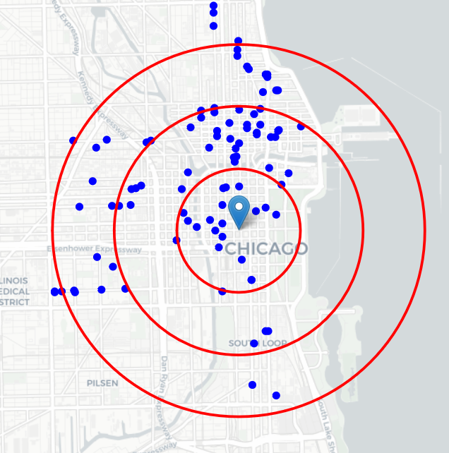
Looks like a few pockets of
low restaurant density closest to city center can be found south, south-west
and east from Chicago.
This map is not so 'hot' (Italian restaurants represent a subset of ~15% of
all restaurants in Berlin) but it also indicates higher density of existing
Italian restaurants directly north and west from Chicago, with closest pockets
of low Italian restaurant density positioned west, south-west and south from
city center.
Based on this we will now focus our analysis on areas south-west, south,
south-west and west from East Chicago - we will move the center of our area
of interest and reduce it's size to have a radius of 2.5km. This places
our location candidates mostly in boroughs with large low restaurant density
north-east from city center, however this borough is less interesting to
stakeholders as it's mostly residental and less popular with tourists).
Let's also create new, more dense grid of location candidates restricted to
our new region of interest (let's make our location candidates 100m appart).
2261
candidate neighborhood centers generated.
OK. Now let's calculate two most important things for each location
candidate: number of restaurants in vicinity (we'll use radius of 250
meters) and distance to closest Italian restaurant.
|
Latitude
|
Longitude
|
X
|
Y
|
Restaurants nearby
|
Distance to Italian restaurant
|
|
|
0
|
41.888612
|
-87.599506
|
-5.378761e+06
|
1.151838e+07
|
0
|
2309.738962
|
|
1
|
41.889200
|
-87.599768
|
-5.378661e+06
|
1.151838e+07
|
0
|
2250.715085
|
|
2
|
41.885207
|
-87.598744
|
-5.379311e+06
|
1.151847e+07
|
0
|
2581.475998
|
|
3
|
41.885795
|
-87.599006
|
-5.379211e+06
|
1.151847e+07
|
0
|
2544.602881
|
|
4
|
41.886383
|
-87.599269
|
-5.379111e+06
|
1.151847e+07
|
0
|
2474.524827
|
|
5
|
41.886972
|
-87.599531
|
-5.379011e+06
|
1.151847e+07
|
0
|
2405.015060
|
|
6
|
41.887560
|
-87.599794
|
-5.378911e+06
|
1.151847e+07
|
0
|
2337.717212
|
|
7
|
41.888148
|
-87.600056
|
-5.378811e+06
|
1.151847e+07
|
0
|
2272.827772
|
|
8
|
41.888736
|
-87.600318
|
-5.378711e+06
|
1.151847e+07
|
0
|
2210.558844
|
|
9
|
41.889324
|
-87.600581
|
-5.378611e+06
|
1.151847e+07
|
0
|
2151.138007
|
OK. Let us now filter those locations: we're interested only in locations
with no more than two restaurants in radius of 250 meters, and no
Italian restaurants in radius of 400 meters.
Locations
with no more than two restaurants nearby: 1265
Locations
with no Italian restaurants within 400m: 1262
Locations
with both conditions met: 1110
Let's see how this looks on a map.

Looking good. We now have a bunch of locations fairly close to East Chicado
(mostly in Quincy and south-west corner of Mitte boroughs), and we know that
each of those locations has no more than two restaurants in radius of 250m, and
no Italian restaurant closer than 400m. Any of those locations is a potential
candidate for a new Italian restaurant, at least based on nearby competition.
Looking good. What we have now is a clear indication of zones with low
number of restaurants in vicinity, and no Italian restaurants at all
nearby.
Let us now cluster those locations to create centers of zones
containing good locations. Those zones, their centers and addresses will be
the final result of our analysis.

Our clusters represent groupings of most of the candidate
locations and cluster centers are placed nicely in the middle of the zones
'rich' with location candidates.
Addresses of those cluster centers will be a good starting point for
exploring the neighborhoods to find the best possible location based on
neighborhood specifics.
Let's see those zones on a city map without heatmap, using shaded areas to
indicate our clusters:

Let's zoom in on candidate areas in Quincy:

Finaly, let's reverse geocode those candidate area centers to get the
addresses which can be presented to stakeholders.
==============================================================
Addresses of
centers of areas recommended for further analysis
==============================================================
880 S Lake
Shore Dr, Chicago, IL 60611
=> 2.2km from East Chicago
Unnamed
Road, Chicago, IL 60601
=> 2.6km from East Chicago
Unnamed Road,
Chicago, IL 60611
=> 3.7km from East Chicago
Chicago, IL
60605
=> 2.7km from East Chicago
447 S
Columbus Dr, Chicago, IL 60612
=> 1.2km from East Chicago
Cook County,
IL => 3.5km from East
Chicago
603 E North
Water St, Chicago, IL 60611
=> 2.4km from East Chicago
840 E Grand
Ave, Chicago, IL 60611
=> 3.7km from East Chicago
235 S
LaSalle St, Chicago, IL 60604
=> 0.3km from East Chicago
Cook County,
IL
=> 3.2km from East Chicago
1000 S
Columbus Dr, Chicago, IL 60605
=> 1.7km from East Chicago
101 N Lake
Shore Dr, Chicago, IL 60601
=> 1.8km from East Chicago
Unnamed
Road, Chicago, IL 60601
=> 2.0km from East Chicago
791 N Lake
Shore Dr, Chicago, IL 60611
=> 3.5km from East Chicago
Heliport,
Chicago, IL 60601
=> 2.9km from East Chicago
This concludes our analysis. We have created 15 addresses representing
centers of zones containing locations with low number of restaurants and no
Italian restaurants nearby, all zones being fairly close to city center (all
less than 4km from east Chicago, and about half of those less than 2km from
east Chicago). Although zones are shown on map with a radius of ~500 meters
(green circles), their shape is actually very irregular and their
centers/addresses should be considered only as a starting point for exploring
area neighborhoods in search for potential restaurant locations. Most of the
zone is located in Quincy boroughs, which we have identified as interesting due
to being popular with tourists, fairly close to city center and well connected
by public transport.

Our analysis shows that although there is a great number of restaurants in
Chicago (~2000 in our initial area of interest which was 12x12km around East
Chicago), there are pockets of low restaurant density fairly close to city
center. Highest concentration of restaurants was detected north and east from
East Chicago, so we focused our attention to areas south, south-west and west,
corresponding to borough Quincy, but our attention was focused on Quincy which
offer a combination of popularity among tourists, closeness to city center,
strong socio-economic dynamics and a number of pockets of low restaurant
density.
After directing our attention to this more narrow area of interest
(covering approx. 5x5km south-west from East Chicago) we first created a dense
grid of location candidates (spaced 100m appart); those locations were then
filtered so that those with more than two restaurants in radius of 250m and
those with an Italian restaurant closer than 400m were removed.
Those location candidates were then clustered to create zones of interest
which contain greatest number of location candidates. Addresses of centers of
those zones were also generated using reverse geocoding to be used as
markers/starting points for more detailed local analysis based on other
factors.
Result of all this is 15 zones containing largest number of potential new
restaurant locations based on number of and distance to existing venues - both
restaurants in general and Italian restaurants particularly. This, of course,
does not imply that those zones are actually optimal locations for a new
restaurant! Purpose of this analysis was to only provide info on areas close to
East Chicago but not crowded with existing restaurants (particularly Italian) -
it is entirely possible that there is a very good reason for small number of
restaurants in any of those areas, reasons which would make them unsuitable for
a new restaurant regardless of lack of competition in the area. Recommended
zones should therefore be considered only as a starting point for more detailed
analysis which could eventually result in location which has not only no nearby
competition but also other factors taken into account and all other relevant
conditions met.
Purpose of this project was to identify Chicago areas close to center with
low number of restaurants (particularly Italian restaurants) in order to aid
stakeholders in narrowing down the search for optimal location for a new
Italian restaurant. By calculating restaurant density distribution from
Foursquare data we have first identified general boroughs that justify further
analysis (Quincy), and then generated extensive collection of locations which
satisfy some basic requirements regarding existing nearby restaurants.
Clustering of those locations was then performed in order to create major zones
of interest (containing greatest number of potential locations) and addresses
of those zone centers were created to be used as starting points for final
exploration by stakeholders.
Final decission on optimal restaurant location will be made by stakeholders
based on specific characteristics of neighborhoods and locations in every
recommended zone, taking into consideration additional factors like
attractiveness of each location (proximity to park or water), levels of noise /
proximity to major roads, real estate availability, prices, social and economic
dynamics of every neighborhood etc. Another important decision factor is the
economic factor, in this study budgets have not been taken into account, since
the area that may need more money can be determined.